सञ्चिका:Mauryan Empire Map.gif

भारतपीडिया तः
नेविगेशन पर जाएँ खोज पर जाएँ

Mauryan_Empire_Map.gif(४०० × ३३७ चित्राणवः (pixels), सञ्चिकायाः आकारः: ११ KB, MIME-प्रकारः: image/gif)

विकिमीडिया कॉमन्स इत्यतः उद्धृता एषा सञ्चिका अन्येषु प्रकल्पेषु उपयोगार्हा । अस्याः सञ्चिकायाः सञ्चिकाविवरणपृष्ठम् इत्यत्र उपलभ्यमानं विवरणम् अधोलिखितं वर्तते ।

Atlas This map has been uploaded by Electionworld from en.wikipedia.org to enable the Wikimedia Atlas of the World . Original uploader to en.wikipedia.org was Vastu, known as Vastu at en.wikipedia.org. Electionworld is not the creator of this map. Licensing information is below.

सारांशः

वर्णनम्
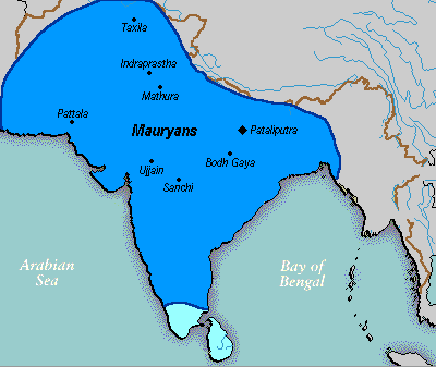
English: A political map of the Mauryan Empire, including notable cities, such as the capital Pataliputra, and site of the Buddha's enlightenment.
this mapis really hard to find txd Green blue represents notable rivers, black represetns modern political borders, and brown represents the border of South Asia. Pataliputra, Sanchi, Ujjain, Bodh Gaya, [[:w:Taxila]|Taxila]]], Mathura, Indraprastha and Pattala Kaushambi, [pryag] are shown.
दिनाङ्क File was made on 03 August 2006, using Paint (software).
स्रोतः Based upon common political maps of the Mauryan Empire, created from this template: Image:Marathas.GIF
लेखकः
अन्यानि संस्करणानि

अनुमतिदानम्

Public domain इदं कार्यं अत्र योजितं सार्वजनिकक्षेत्रम् अस्य कर्त्रा, Vastu । इदं जागतिकस्तरे आन्वितं भवति ।

केषुचित् देशेषु इदं न्यायालयदृष्ट्या असाध्यं स्यात् ; यदि तथा :
निर्बन्धं विना अस्याः कृतेः उपयोगं यःकोपि कस्यापि निमित्तं उपयोक्तुम् अनुमतिं Vastu यच्छति न्यायविधेः निर्बन्धः यदि न स्यात् ।

Captions

Add a one-line explanation of what this file represents

Items portrayed in this file

चित्रण हिन्दी

MIME type आङ्ग्लभाषा

image/gif

सञ्चिकायाः इतिहासः

सञ्चिका तत्समये कीदृशी आसीदिति द्रष्टुं दिनाङ्कः/समयः नुद्यताम् ।

दिनाङ्कः/समयःलघ्वाकृतिःआयामाःसदस्यःटिप्पणी
वर्तमानः०५:४६, २५ मार्च् २०१६०५:४६, २५ मार्च् २०१६ इत्यस्य संस्करणस्य लघुस्वरूपम् ।४०० × ३३७ (११ KB)wikimediacommons>LouisAragonrv, changes made by a banned user.

2 अधो निर्दिष्टपृष्ठानां परिसन्धिः संलग्ना अस्ति:
"https://sa.bharatpedia.org/wiki/सञ्चिका:Mauryan_Empire_Map.gif" इत्यस्माद् प्रतिप्राप्तम्